Principal Investigators: William P. White
Project Staff: Denise Devotta, Joy Miller, John Beardsley, Jon Rodsater, Long Duong
Collaborating Agencies: Illinois State Geological Survey, Illinois State Natural History Survey
Sponsor: Illinois Department of Natural Resources
Project Period: October 2003 - June 2009

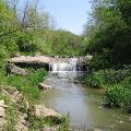
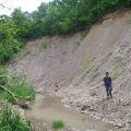
This project is designed to perform assessments in the Illinois River Basin including the tributary watersheds to identify project locations for restoration related construction to meet overall goals and objectives of the Illinois River Basin and Tributaries Ecosystem Restoration Project. The intent is to bring focus and coordinated integration to the assessment efforts. The watershed assessment efforts include collection and analysis of data to specifically be used to locate, scientifically describe, prioritize, and provide guidance in design and implementation of on-the-ground, multi-objective, natural resource restoration or naturalization projects that control erosion and sediment transport and restore or enhance habitat and overall ecosystem health of the basin.

Findings to Date:
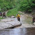
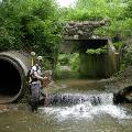
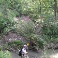
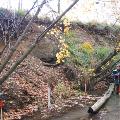
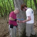
Stream and near-channel aerial reconnaissance, using GPS for location information, was acquired on 1,727.40 stream miles (2,779.97 km) of selected streams from 2004 to 2008 (see Stream and Watershed Assessments and Restoration (SWAR) Video and Photo Documentation). Throughout the contract period field crews covered 83.83 stream miles (134.91 km) while assessing 433 station locations. Numerous potential restoration sites were identified for further consideration. Aerial imagery and field-based geomorphological and biological data collection were added to the Illinois Rivers Decision Support System which will allow resource managers to make timely and better decisions regarding restoration priorities, designs, adaptive management needs, and overall performance evaluations.

Project Publications:
White, W. P., M. Demissie, and L. L. Keefer, 2005a, Illinois River Basin Assessment Framework: In Proceedings of the Governor's Conference on the Management of the Illinois River System. Illinois Rivers Decision Support System; October, 2005. Peoria, Illinois.
White, W. P. and L. L. Keefer, 2005b, Rapid Stream Assessments of the Illinois River Watershed: In Proceedings of the World Water & Environmental Resources Congress 2005: Impacts of Global Climate Change. Conference of the Environmental & Water Resources Institute of the American Society of Civil Engineers, May 15-19, 2005. Anchorage, Alaska, USA.
Stumpf A. J., A. C. Phillips, G. E. Pociask, L. R. Smith, W. P. White, 2006, Mass wasting and its control on channel behavior and valley formation in the Partridge Creek watershed, Illinois River Valley, Illinois, 2nd Shlemon Specialty Conference in Engineering Geology, Durango, Colorado, Quaternary Geology Section, Illinois State Geological Survey, Champaign, IL
White, W.P., 2007, Senachwine Creek: A Case Study of Watershed Assessment in the Illinois River Basin; n Proceedings of the Governor's Conference on the Management of the Illinois River System. Illinois Rivers Decision Support System; October, 2007. Peoria, Illinois.
White, W.P., A. C. Phillips, and J. Beardsley, 2007, Senachwine Creek Watershed Assessment: A Framework for Project Identification and Restoration of Watersheds in the Illinois River Basin: World Environmental & Water Resources Congress, EWRC-ASCE, Tampa, Florida
White, W. P., A. C. Phillips, J. D. Beardsley, D. Devotta, G. E. Pociask, 2011, “Draft”, Senachwine Creek Watershed Assessment Report, Illinois State Water Survey, Institute of Natural Resource Sustainability, University of Illinois, Champaign-Urbana, Ill
Keefer, L.L., W. P. White, J. D. Beardsley, 2011, “Draft v.3”, Illinois River Basin Ecosystem Restoration Geomorphic Watershed Assessment (IRBGWA) Protocols. Illinois State Water Survey, Institute of Natural Resource Sustainability, University of Illinois, Champaign-Urbana, Ill
White, W. P., A. C. Phillips, J. D. Beardsley, G. Sass, G. Pociask, 2011, “Draft”, Tenmile Creek Watershed Assessment Report, Illinois State Water Survey, Institute of Natural Resource Sustainability, University of Illinois, Champaign-Urbana, Ill
White, W. P., A. C. Phillips, D. Devotta, 2009, Watershed Assessment, Article in Outdoor Illinois Magazine, Illinois State Water Survey, Institute of Natural Resource Sustainability, University of Illinois, Champaign-Urbana, Ill

Related Publications:
Contributors: Esarey, Duane; Holm, Nancy; Keefer, Laura; Meschewski, Elizabeth; Phillips, Andrew; Stein, Jeffrey; Winkel, Richard; Abrams, Daniel; Bauer, Erin; Beardsley, John; Benson, T.J.; Beveroth, Tara; Bhowmik, Nani; Casper, Andrew; Cao, Yong; Cummings, Kevin; Davisson, Diana; Dreslik, Michael; Getahun, Elias; Hinz, Leon; Knapp, Vern; McConkey, Sally; Markus, Momcilo; Marlin, John; Metzke, Brian; Phillips, Chris; Tiemann, Jeremy; Ward, Michael; Wilm, Brian; Yetter, Aaron, 2017, Assessing Progress on the 1997 Integrated Management Plan for the Illinois River Watershed, Prairie Research Institute, Champaign-Urbana, Illinois.
Illinois River Basin Restoration Comprehensive Plan with Integrated Environmental Assessment, 2007, U.S. Army Corps of Engineers, Rock Island, Illinois.
Phillips, A. C., B. L. Rhoads, T. J. McTighe, C. A. Klaus, 2002, Stream Dynamics Assessment in the Illinois River Basin, Illinois State Geological Survey, Champaign-Urbana, Illinois.
Contributors: Kingsley Allan, Nani Bhowmik, Edward Chen, R. Misganaw Demissie, Edward DeWalt, Joyce Freese, Linda Hascall, Beverly Herzog, Christopher Jennings, Eva Kingston, H. Vernon Knapp, Yanqing Lin, John Marlin, Kevin Merrifield, Paminder Parmar, Christopher Tidrick, Melinda Tidrick, derek Winstanley, Bill White, 2002, Illinois Rivers Decision Support System (ILRDSS), Illinois State Water Survey, Illinois Natural History Survey, Illinois State Geological Survey, Waste management and Research Center, Champaign- Urbana, Illinois
Integrated Management Plan for the Illinois River, 1997, Lieutenant Governor Bob Kustra et al., Springfield, Illinois
Integrated Management Plan for the Illinois River Watershed Technical Report, 1997, Lieutenant Governor Bob Kustra et. al, Springfield, Illinois