Eastern Mahomet Aquifer Groundwater Monitoring
With funding provided by Illinois American Water- Champaign, ISWS monitors water levels at a network of observation wells in the eastern Mahomet aquifer and overlying Glasford aquifer. The main purpose of the network is to collect long-term data to study how the aquifer is impacted by large groundwater withdrawals from public, industrial, and irrigation use. This monitoring also helps ISWS scientists determine how the aquifer is recharged, how it interacts with streams, and how it responds to droughts and floods. The observation well network consists of wells open to the Mahomet aquifer and overlying Glasford aquifer. Many of these sites are nested sites, meaning there are Mahomet and Glasford wells located at the same location, allowing vertical gradients to be established.
The ISWS initiated monitoring water levels in the Mahomet aquifer just west of Champaign in 1953 to help resolve a dispute between the petro-chemical company in Tuscola and the water utility serving Champaign and Urbana. In the 1990s, interest in understanding groundwater flow prompted state funding of the Aquifer Assessment Program, leading to the Development of an observation well network in the Mahomet Aquifer of East-Central Illinois. This monitoring network was greatly expanded in 2007-2009, particularly in Champaign County, with funding from Illinois American Water- Champaign.
Real-Time Monitoring Wells
The following wells are equipped with real-time data (see map below for locations). Click on a well to view the hydrograph and download the data.
- CHAM-07-04B (Bondville)
- CHAM-07-01A (Zahnd Pond)- Mahomet
- CHAM-07-01C (Zahnd Pond)- Glasford
- CHAM-08-02A (Middle Fork FP East)- Mahomet
- CHAM-08-02B (Middle Fork FP East)- Glasford
- CHAM-08-03A (S of Ludlow)- Mahomet
- CHAM-08-03B (S of Ludlow)- Glasford
- CHAM-08-08A (Lake of the Woods FP)- Mahomet
- CHAM-08-08B (Lake of the Woods FP)- Glasford
- CHAM-08-09A (Sangamon River)- Mahomet
- CHM-95B (North Mattis)- Mahomet
- CHAM-08-06 (North Mattis)- Glasford
- CHAM-09-03A (Orr Farms)- Mahomet
- CHAM-09-03C (Orr Farms)- Henry/Glasford
- CHAM-09-05A (Stanton Township Garage)
- CHAM-12-02A (Dillsburg)- Mahomet
- CHAM-12-02C (Dillsburg)- Glasford
- CHAM-20-01 (Dewey New Site)
- CHM-96A (Dewey Old Site)
- CHM-95D (Seymour)
- CHM-96C (County Line)
- IRO-98C (Crescent City)
- PIA-2000A (Cisco)
- PIAT-09-01A (Railroad Museum)- Mahomet
- PIAT-09-01B (Railroad Museum)- Glasford
- Petro North
- Petro South
- VERM-08-01A (Armstrong)
In addition, these hydrographs can be accessed through the ISWS interactive map of observation wells.
Additional Information
Below are relevant monitoring and modeling reports related the eastern Mahomet aquifer.
- Anomalous groundwater pressure responses in the Mahomet Aquifer near the Manlove Gas Storage Field
- Champaign Water Levels 2009-2014
- Potential impacts on the Mahomet Aquifer and surface reservoirs
- 2012 Drought in Illinois
This video shows the daily deviation in groundwater levels from the mean aquifer level at each of the wells monitoring with pressure transducers. It shows the response of the aquifer to flooding in Piatt County, irrigation in Champaign County, and pumpage by the city of Decatur in DeWitt County.
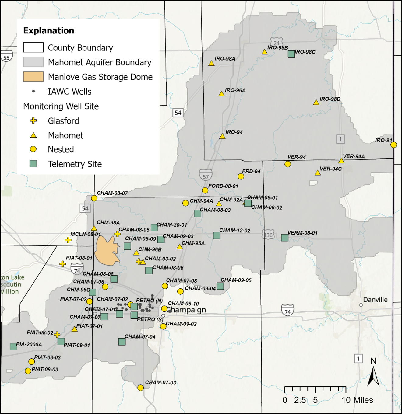
Map of the observation well network in the eastern Mahomet aquifer and the current sites with telemetry stations.