Jacksonville
System Information
System Description
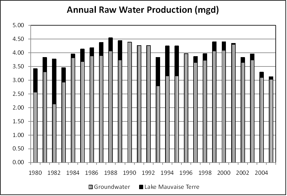
Most of the community's supply comes from groundwater, but Mauvaise Terre Lake supplies water during higher demand periods. Lake Jacksonville is used only to increase levels in Mauvaise Terre Lake during emergencies. A valve at the 11 mgd treatment plant lets in additional water from Mauvaise Terre Lake as needed.
Satellite Communities and Water Districts
Alexander WD, Chapin, Concord, Franklin, Murrayville-Woodson Water Commission, North Morgan WD, and SMG WD
Population Served: |
23000 |
County: |
Morgan |
Watersheds: |
Illinois |
Water Source
| Name |
Type |
Stream |
DA (sq mi) |
SA (ac) |
Capacity |
Year Est. |
Est. 2010 Cap. (ac-ft) |
| Mauvaise Terre Lake |
IR |
Mauvaise Terre Cr |
32.6 |
143 |
627.9 |
1979 |
281.2 |
| Lake Jacksonville |
IR |
Sandy Cr |
10.8 |
465 |
5830 |
1986 |
5435 |
| Groundwater |
GW |
|
|
|
|
|
|
1989 Study: |
50-year drought yield sufficient at present level of water use. |
USGS Gages: |
No data available |
Developments since 1989:
The city is considering dredging Mauvaise Terre Lake. The newly formed North Morgan County RWD connected to the system in 2007. Although groundwater access buffers the community from drought hardships, storage from Lake Jacksonville had to be released into Mauvaise Terre Lake during the 2005 drought.
Notes and Terminology
Vulnerability Report
Choose another Community

