Illinois State Water Survey - University of Illinois at Urbana-Champaign
State Climatologist Office for Illinois
El Niño and La Niña in Illinois
Dr. Jim Angel, State Climatologist
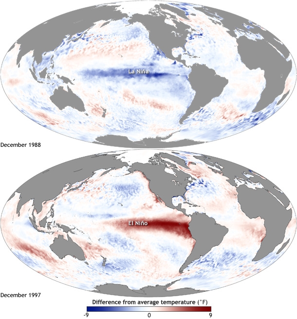
El Niño and La Niña refer to periods when sea-surface temperatures along the equator in the Pacific Ocean are either unusually cold for La Niña (top panel in figure) or unusually warm for El Niño (bottom panel in figure). These change the weather patterns over the Pacific Ocean, which in turn changes the weather patterns for much of the rest of the world. These events typically begin in the spring or summer and fade by the following spring.
While this page gives some general information, the best places to see ongoing discussions about developing events and their impacts on Illinois are through my blog, twitter feed, the NWS Climate Prediction Center, the climate.gov ENSO blog, and the Midwestern Regional Climate Center.
Global Impacts of El Niño
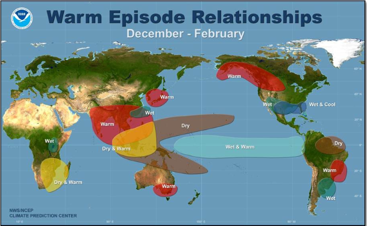
The impacts of El Niño are truly global as the figure shows for Northern Hemisphere winter. Large areas of Africa, Asia, Australia and parts of South American can be warmer and drier than average. Meanwhile, in North America warmer than average weather extends from Alaska through the central US, while most of the southern tier of states in the US are cooler and wetter. These are general conditions associated with El Niño. However, no two events are ever the same in terms of timing, strength, and area. Therefore, it is best to consult the NWS Climate Prediction Center seasonal forecasts for the best information on developing conditions.
Summary of Impacts of El Niño
El Niño events vary in size, intensity, and duration. As a result, the impacts can vary from one event to the next. In addition, there may be other factors that influence Illinois weather during these events.
- Summers tend to be slightly cooler and wetter than average
- Falls tend to be wetter and cooler than average
- Winters tend to be warmer and drier
- Springs tend to be drier than average
- Snowfall tends to be below average
- Heating degree days tend to be below average, which means lower heating bills.
Summary of Impacts of La Niña
Generally, La Niña impacts are not as clear-cut because there are fewer strong ones in recent years (1970-71, 1973-74, 1975-76, 1988-89).
- Summers have a tendency to be warmer and drier in Illinois
- Falls have a tendency to be cooler in the north and wetter in the southeast
- Winters are typically warmer and wetter than average with more snow and winter storms
- Springs tend to be cooler across most of the state and drier in the west
Older Research (To Be Revisited)
There was some older content on this page regarding strong versus weak events, as well as impacts on snow. This was material developed for the last major event of 1997-98 and needs to be updated as time permits.