Imperial Valley Water Authority
Principal Investigators: Michael Krasowski, Erin Bauer, Kevin Rennels, Hideyuki Terashima
Project Staff: Daniel Abrams, Erin Bauer, Kevin Rennels, Emily Winfield, Steve Wilson, Hideyuki Terashima
Sponsor: The Imperial Valley Water Authority
Project Period: June 1992 – current
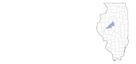
The Illinois State Water Survey (ISWS), under contract to the Imperial Valley Water Authority (IVWA), has operated a network of rain gauges in Mason and Tazewell Counties since August 1992 and a network of groundwater observation wells since 1994. The purpose of the rain gauge and groundwater observation well networks is to collect long-term data to determine the impact of groundwater withdrawals during dry periods and during the growing season, and the rate at which the aquifer recharges.
Data
View real-time water level hydrographs for Imperial Valley.
Daily precipitation observations from the Imperial Valley Precipitation gages are available from the Imperial Valley Precipitation Network Daily Data Archive (1992-2016).
Findings to Date
Transducers that allow for near continuous measurement of water levels in monitoring wells have allowed us to correlate the timing of rainfall to changes in aquifer levels. These data indicate that, depending on location and time of year, rainfall events can have a significant effect on recharge to the aquifer.
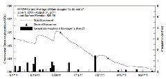 Water
level changes can occur within a day of the rainfall event. Data are being collected to establish a relationship among depth to the water table, time of year, and magnitude of rainfall events, to better predict aquifer recharge. The figure at right
shows an example of water level changes in the aquifer due to rainfall (from Year 19 — click image to see enlarged version).
Project Letters and Publications
In 2009, the Illinois State Water Survey began providing annual project update letters to the Imperial Valley Water Authority in lieu of Contract Reports. See all the letters and publications from this project.
