Decatur
System Information
System Description
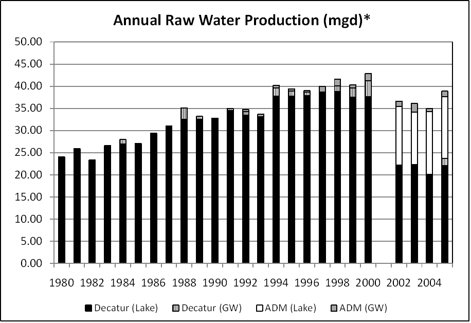
Water from Lake Decatur is pumped to a 36 mgd treatment plant. Archer Daniels Midland (ADM), a separate system, is allotted 19 mgd from the lake and purchases additional water from Decatur. During droughts, water is available from the DeWitt well field, and the Vulcan and Lake Tokorozawa gravel pits.
Satellite Communities and Water Districts
Harristown, Long Creek, Mount Zion
Population Served: |
90243 |
County: |
Macon |
Watersheds: |
Sangamon |
Water Source
| Name |
Type |
Stream |
DA (sq mi) |
SA (ac) |
Capacity |
Year Est. |
Est. 2010 Cap. (ac-ft) |
| Lake Decatur |
IR |
Sangamon R |
925 |
3093 |
20960 |
2003 |
20960 |
| DeWitt Well Field |
GW |
|
|
|
|
|
|
| Vulcan Gravel Pit* |
QBP |
N/A |
|
|
920 |
|
|
| Lake Tokorozawa* |
QBP |
N/A |
|
|
2000 |
|
|
1989 Study: |
20-year drought yield insufficient at present level of water use. |
USGS Gages: |
Sangamon River at Monticello (05572000) |
Developments since 1989:
Mandatory use restrictions were implemented in 1988 and 2007 while voluntary ones were requested in 1999 and 2000. The normal pool elevation was raised from 613.5 to 614.3 feet. Ongoing dredging projects maintain the reservoir's storage volume. A 6,200 ac-ft off-channel reservoir and an intake in the lower portion of the lake have been proposed.

Note: *Withdrawals for Decatur and ADM are shown separately to illustrate the impact the two systems may have on water availability in Lake Decatur. Production from ADM's wells is also shown.
Notes and Terminology
Vulnerability Report
Detailed Analysis
Choose another Community

