Paris
System Information
System Description
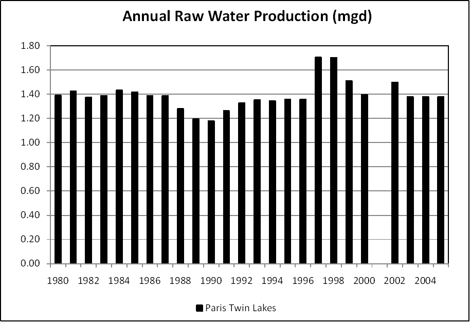
Paris is no longer producing its own surface water. Prior to 2010, the Paris Twin Lakes was operated as one lake with the East Lake's dam controlling the reservoir pool elevation. Water could travel to the treatment plant at up to 2000 gpm. West Lake, whose capacity increased from 150 ac-ft to 231 ac-ft after a 1991 dredging project, effectively serves as a sedimention basin for East Lake downstream.
Satellite Communities and Water Districts
None
Population Served: |
9077 |
County: |
Edgar |
Watersheds: |
Wabash |
Water Source
| Name |
Type |
Stream |
DA (sq mi) |
SA (ac) |
Capacity |
Year Est. |
Est. 2010 Cap. (ac-ft) |
| Paris Twin Lakes |
IR |
Sugar Cr |
22 |
232 |
1639 |
1991 |
1498.9 |
1989 Study: |
20-year drought yield insufficient at 1990 level of water use. |
USGS Gages: |
No data available |
Developments since 1989:
The community now uses a new groundwater system that withdraws water from a Wabash Valley aquifer well field (not under surface water influence) in Indiana.
Notes and Terminology
Vulnerability Report
Choose another Community

