Charleston
System Information
System Description
Water is typically pumped from Lake Charleston, a low channel dam impoundment in the Embarras River, to the Charleston Side Channel Reservoir (CSCR), an off-channel reservoir, at 4,000 gpm before being relayed to the community's new 4.5 mgd treatment plant at up to 3,125 gpm. If necessary, two pumps can fill the off-channel reservoir at 7,500 gpm.
Satellite Communities and Water Districts
Eastern Illinois University and Long Acre Estates
Population Served: |
21520 |
County: |
Coles |
Watersheds: |
Embarras |
Water Source
| Name |
Type |
Stream |
DA (sq mi) |
SA (ac) |
Capacity |
Year Est. |
Est. 2010 Cap. (ac-ft) |
| Lake Charleston |
RW |
Embarras R |
786 |
94 |
226 |
|
226 |
| Off-Channel Res. |
OCR |
Embarras R Trib |
1.77 |
339 |
2871 |
1988 |
2871 |
1989 Study: |
50-year drought yield sufficient at present level of water use. |
USGS Gages: |
Embarras River near Diona (03344000) and at Ste. Marie (03345500) |
Developments since 1989:
A new treatment plant eliminated a chronic taste and odor problem in 2005. Several CSCR locations have received shoreline erosion treatment since 1991, and a sedimentation basin was built in its northwest cove. Eastern Illinois University implemented a conservation program 2006. There are plans to build an emergency connection with Mattoon.

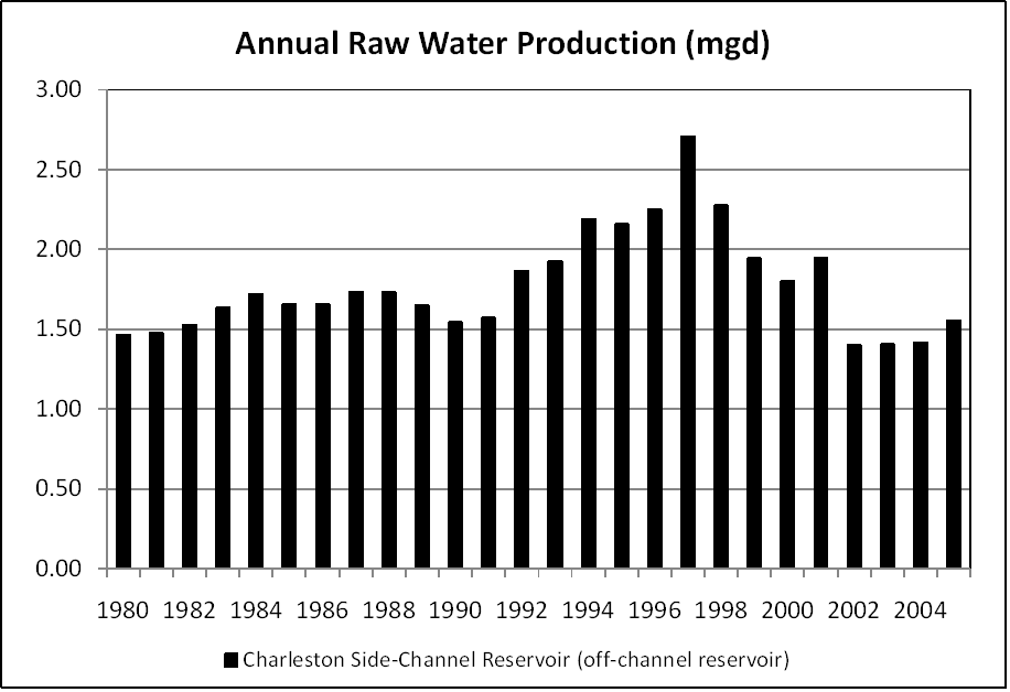
Note: *Poor meter locations in old treatment plant may have overestimated production by 0.3 mgd prior to April 2005.
Notes and Terminology
Vulnerability Report
Choose another Community

