Lake-Effect Snow Storms Field Research
David Kristovich
Lake-effect snowstorms, which develop over the Great Lakes each winter, bring some of the most extreme winter weather seen in central and eastern North America. Accurate forecasts can allow residents and communities to prepare for storms by stocking up on food and water, staging snow removal equipment, and preparing for emergency services. While computational models available to the National Weather Service have much skill predicting IF a lake-effect storm will occur, forecasts of what locations will be most affected, how much snow will fall, and the intensity of the storm remain difficult challenges.
Ongoing studies at ISWS as part of the Ontario Winter Lake-effect Systems (OWLeS) field project, a collaboration of nine universities, examine processes involved in the development and evolution of lake-effect snow storms, such as the evolution of snow bands, snow growth processes, and the influences of natural cloud seeding from above. Recent efforts have provided unique insights on the evolution of lake-effect convection and precipitation, key transitions in the atmosphere’s response to different surface characteristics, and impacts of the lake on lake-effect snow and boundary layer depth.
Observations from the ground and from airplanes are designed to help scientists understand the relationships between the amount of moisture moving upward into the atmosphere from the lake surface, the depth of storms, and the amount of snow the storms produce. These observations and studies will lead to improved forecasts for areas affected by lake-effect snowstorms.
Recent work focuses on accurately describing different types of lake-effect systems based on turbulent characteristics of the atmosphere in and above the storm, quantifying the formation of liquid and ice clouds and snow, and understanding the entrainment layer, through which most growth of the lake-effect storm occurs. They are especially seeking to understand how much snow from nearby cyclones alters and intensifies snow from lake-effect storms.
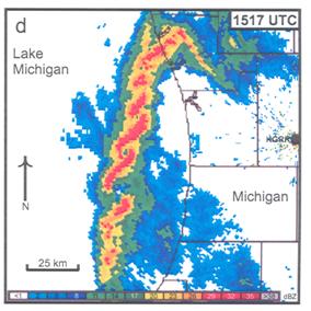 Radar observations of vortices forming along a lake-effect snow band. From Grim et al. (2004, Monthly Weather Review)
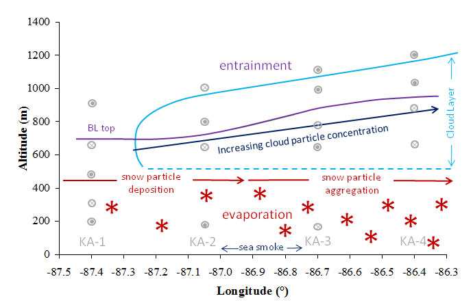 Schematic of cloud and snow growth processes as cold air flows from west (left) to east (right) across Lake Michigan on 10 January 2008. Modified from Barthold and Kristovich (2011, Monthly Weather Review)
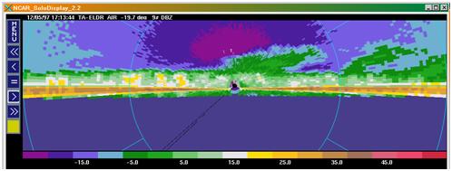 NCAR ELDORA Observations of snow from a higher-level cloud deck seeding a lower layer of lake-effect snow. Brighter colors denote heavier snow. The bright horizontal lines are radar returns from the surface of Lake Michigan. From Schroeder, Kristovich,
and Hjelmfelt (2006, Monthly Weather Review)
NCAR ELDORA Observations of snow from a higher-level cloud deck seeding a lower layer of lake-effect snow. Brighter colors denote heavier snow. The bright horizontal lines are radar returns from the surface of Lake Michigan. From Schroeder, Kristovich,
and Hjelmfelt (2006, Monthly Weather Review)