The Illinois State Water Survey has been a leader in the study of water resources, weather, and climate for 125 years.
1895: The Illinois State Water Survey traces its start back to 1895 when the Illinois legislature appropriated $5,000 to the University of Illinois, earmarking $4,000 to study the state's water supply. In 1897, An Act to Establish a Chemical Survey of the Waters of the State of Illinois appropriated an additional $3,000 and directed “chemical and biological survey of the waters of the State.”
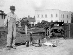
 1910: The Water Survey’s
original mission was to trace the spread of waterborne disease, particularly typhoid fever. Typhoid was a particular problem in rural southern Illinois, but Chicago also had a high rate of the disease. By 1910, Water Survey staff had tested more than
21,000 water samples from 971 towns in all of the state’s 102 counties. Many wells were condemned due to combinations of high levels of bacteria and minerals.
1917: The Water Survey (along with the Natural History Survey and Geological Survey) was transferred to the Illinois Department of Registration and Education.
1930s: The Dust Bowl Decade resulted in a shortage of both surface and groundwater supplies in many parts of the state. The Water Survey was instrumental in advising local municipalities and water resource professionals on management strategies, publishing the state’s first inventory of municipal groundwater supplies. ISWS staff also conducted a sediment survey of Lake Decatur (the first such survey ever made by a state agency).
1949: A water treatment advisory service for state institutions began, saving the state thousands of dollars annually by recommending treatments for water heating and cooling systems.
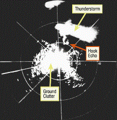
 1953: On April 9, 1953, ISWS radar operators were testing radar equipment to measure rainfall rates. As they focused on a large thunderstorm passing north of Champaign, the radar showed a large hook-shaped echo emerging from the
thunderstorm. A hook echo is a classic sign of tornado development, and in this case turned out to be the funnel of a large, developing tornado that moved 54 miles to the east. This was the first time in the U.S. that a tornado had been detected and
photographed by radar.
 1954: The U.S. Weather Bureau established a "state climatologist" in each state to help state agencies and university scientists with climate data and
information. Today the office of the Illinois State Climatologist provides weather and climate data, maps, and information for Illinois farmers, government agencies and policymakers, and all citizens and acts as the state’s authoritative spokesperson
on climate science. The first Illinois State Climatologist was Paul Sutton. Stanley Changnon served as state climatologist from 1972 to 1980, followed by Wayne Wendland from 1981 to 1996. Jim Angel was the longest-serving state climatologist, filling
the role from 1996 to 2018. Current Illinois State Climatologist Trent Ford took on the position in 2019.
1956: Civil engineer William C. Ackermann was appointed to lead the Water Survey in 1956.
1963: William Walton and Thomas Prickett constructed electric analog groundwater models. In these models, the flow of electricity through an intricate network of wires, resistors, and capacitors represents the flow of water through porous geological formations with varying hydraulic properties. In the early 80s, their 1963 publication on this work in the Proceedings of the American Society of Civil Engineers was selected as a benchmark contribution to classic literature in the field of hydrogeology.
 1963-1965: In 1963, ISWS director Ackermann went on leave from the survey in order to serve as a water resources
adviser to the Office of the President, working with federal agencies to create the federal government’s first coordinated water research plan. In 1965, Illinois Gov. Otto Kerner made Ackermann the leader of a task force to develop a comprehensive
state plan for water resources. The plan was released in 1965, but because of budget constraints was not implemented.
1968: The Illinois State Water Survey designed and developed the nation’s first Doppler weather radar in 1968. It detected the motion of drops and particles inside a storm so that the formation of tornado funnels aloft could be spotted. The U.S. now has a network of Doppler radars used for detecting and tracking tornadoes.
1970: Scientists devised and tested a unique approach to measuring crop hail losses from aircraft. Findings showed that infrared sensing allows quantification of hail damage. Subsequently, the insurance industry adopted this technique for national use.
1971: Tom Prickett and C.G. Lonnquist developed the Prickett-Lonnquist Aquifer Simulation Model (PLASM), the first digital groundwater flow model. Prickett’s work in finite difference groundwater models set the stage for the development of the now-standards USGS MODFLOW model in the 1980s.
1980s-1990s: Water Survey atmospheric scientists conducted pioneering studies of historic hail data and launched several field projects in Illinois to measure hail and its impacts on crops and property. During this era, the Water Survey also launched the nation’s first program to define the environmental and socioeconomic impacts of weather and climate conditions, information valuable for estimating the impacts of possible future climate changes.
1995: Following a major heat wave in Illinois with record-high numbers of deaths in the Chicago area, scientists conducted atmospheric studies to interpret the event’s climatic severity. The results guided revisions to Chicago’s policies for handling heat waves.
2007: Water Survey scientists Stanley Changnon and Kenneth Kunkel shared in the 2007 Nobel Peace Prize with other contributors through their work with the Intergovernmental Panel on Climate Change. The scientists served as authors, reviewers, or contributors to a series of reports assessing the state of science and impacts of global climate change.
2008: The University of Illinois Scientific Surveys Act transferred the Illinois State Water Survey from the Illinois Department of Natural Resources to the newly established Prairie Research Institute at the University of Illinois Urbana-Champaign, bringing the Water Survey back to its original home.
 2013:
The State Hydrologist position was created by an amendment to the State Surveys Act and ISWS director Misganaw Demissie was the first to fill the role, serving until his retirement in 2016. Current
State Hydrologist Laura Keefer was appointed in 2018. The Illinois State Hydrologist provides science-based information on watersheds, rivers, groundwater,
and other state water resources and leverages the expertise of PRI staff on statewide water issues, such as flooding and contamination.
2017: Kevin C OBrien was appointed to lead the Water Survey. OBrien is also director of the Illinois Sustainable Technology Center.
2023: Laura Keefer was named Deputy Director of the Water Survey.
Learn more about the history of the Illinois State Water Survey on our blog.