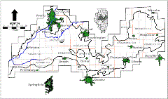
Mahomet Aquifer
The Mahomet aquifer is the major groundwater resource for east-central Illinois. Many communities, industries, and irrigators depend on the aquifer for their supply; withdrawals in 1995 for municipal use are estimated at over 30 mgd. Withdrawals for irrigation, principally in Mason and Tazewell Counties (the Havana Lowlands area), puts usage well over 100 mgd.
A long-term hydrograph at Champaign shows a decline in artesian head of nearly 50 feet since 1950, as a result of increasing water demand in the Champaign-Urbana area. The elevation of the top of the aquifer in this region is at approximately 525 feet, so additional development of the aquifer can continue in the Champaign area for quite some time. Similar, perhaps greater, declines can be expected in other areas of development as use of the aquifer increases.
Groundwater Quality
Water within the Mahomet aquifer is generally of excellent quality, although areas of high ammonia and total organic carbon are known. Arsenic has also been found in some wells, approaching or even exceeding drinking standards. An area northeast of Decatur has been found to contain elevated concentrations of dissolved minerals, possibly as a result of upwelling from the underlying bedrock. The potential for agricultural chemical and nutrient contamination of groundwater is also of concern in the sandy areas of Mason and Tazewell Counties.
Increasing Demands
Population projections suggest that by 2020, the Mahomet aquifer region may increase by 100,000 people to a total of 900,000. Additional demands for water may result as several central Illinois communities currently using surface water reservoirs look to the Mahomet to alleviate reservoir capacity and water quality problems. The additional demands of Springfield, Decatur, Bloomington, and Danville could potentially increase groundwater demands on the Mahomet aquifer by 80 mgd.
Science for Water Resources Management
While the sustained yield of the Mahomet aquifer has been estimated to be in excess of 400 mgd, over-development of the aquifer can occur in localized areas. New field data coupled with computer modeling of the aquifer system is needed to examine development alternatives for community planners. With respect to arsenic, a more detailed description of the distribution of contaminated and uncontaminated areas is needed and effective water treatment methods should be developed for communities in the affected areas. Field sampling, laboratory experiments, and modeling should be done to predict the effects of large-scale withdrawals on the transport of arsenic in the aquifer.
See also: Mahomet Aquifer Consortium
