Marion
System Information
System Description
Marion no longer produces its own surface water and purchases water from the Rend Lake Intercity Water System. Prior to August 2010, City Reservoir was Marion's principal water source. Water purchased from Herrin Lake No. 2 boosted supply when needed.
Satellite Communities and Water Districts
Wye WD (~50%)
Population Served: |
17700 |
County: |
Williamson |
Watersheds: |
Big Muddy |
Water Source
| Name |
Type |
Stream |
DA (sq mi) |
SA (ac) |
Capacity |
Year Est. |
Est. 2010 Cap. (ac-ft) |
| Marion City Res. |
IR |
Limb Br |
6.48 |
240.4 |
1478 |
1970 |
1318.3 |
| Herrin Lake No. 2 |
IR |
Wolf Cr |
3.15 |
50.2 |
240 |
1936 |
470 |
1989 Study: |
20-year drought yield insufficient at 1990 level of water use. |
USGS Gages: |
No data available |
Developments since 1989:
In 2005, mandatory conservation measures were implemented, including car wash shutdowns and outdoor watering bans. Transmission line leaks caused the system to lose water obtained from Herrin Lake No. 2.

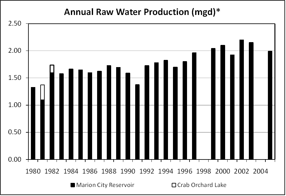
Note: *Crab Orchard Lake was abandoned in the 1980s due to unsafe PCB concentrations. The United States Penitentiary in Marion has its own water system.
Notes and Terminology
Vulnerability Report
Choose another Community

