Litchfield
System Information
System Description
Lake Lou Yaeger, the system's principal water source, conveys water to the 2.7 mgd treatment plant. During most years, water from Litchfield Lake is withdrawn when Lake Lou Yaeger is drawn down 4-5 feet in December to prevent ice damage to the lake's marina.
Satellite Communities and Water Districts
Butler, Henderson WD, Rocky Hollow WD, and Three County WD
Population Served: |
13000 |
County: |
Montgomery |
Watersheds: |
Kaskaskia |
Water Source
| Name |
Type |
Stream |
DA (sq mi) |
SA (ac) |
Capacity |
Year Est. |
Est. 2010 Cap. (ac-ft) |
| Lake Lou Yaeger |
IR |
W Fk Shoal Cr |
115 |
1205 |
13906 |
1977 |
9634.2 |
| Litchfield Lake |
IR |
W Fk Shoal Crk Trib |
1.27 |
33 |
629 |
1995 |
629 |
1989 Study: |
50-year drought yield sufficient at present level of water use. |
USGS Gages: |
No data available |
Developments since 1989:
A new 4 mgd treatment plant is scheduled to go online in August 2008. Its processing capacity could be doubled to 8 mgd if necessary.

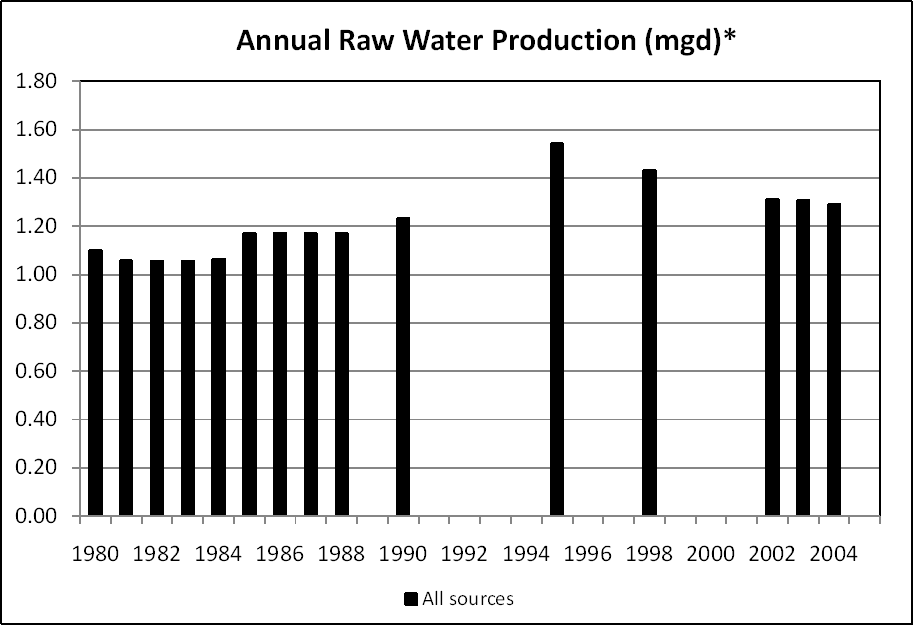
Note: *Lake Lou Yaeger and Litchfield Lake are not metered separately.
Notes and Terminology
Vulnerability Report
Choose another Community

