Taylorville
System Information
System Description
Water from Lake Taylorville is pumped to the treatment plant from either the West pump (2100 gpm) or both the Central (700 gpm) and East (700 gpm) pumps. An additional 800 gpm comes from three rotating drift wells, while water from a fourth well with a high iron concentration is available during emergencies.
Satellite Communities and Water Districts
Bertinelli Addition, Hewittville, Kincaid, Langleyville RWD, Owaneco, and Taylorville Correctional Center
Population Served: |
17500 |
County: |
Christian |
Watersheds: |
Sangamon |
Water Source
| Name |
Type |
Stream |
DA (sq mi) |
SA (ac) |
Capacity |
Year Est. |
Est. 2010 Cap. (ac-ft) |
| Lake Taylorville |
IR |
S Fk Sangamon R |
131 |
1148 |
7535 |
2000 |
|
| Groundwater |
GW |
|
|
|
|
|
|
1989 Study: |
50-year drought yield sufficient at present level of water use. |
USGS Gages: |
No data available |
Developments since 1989:
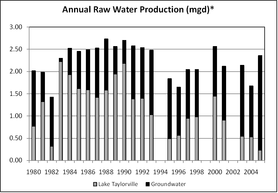
The Taylorville Water Department hopes that the installation of two large and 13 small sedimentation basins reduces the reservoir sedimentation rates by 80%. The city plans to continue using the lake as a regular source in spite of increased groundwater withdrawals. Ample groundwater resources protect the community from drought.

Note: *Water production declined after the ADM plant moved in 1995. High water treatment costs and subsequent price increases have reduced surface water withdrawals in recent years.
Notes and Terminology
Vulnerability Report
Choose another Community

